Manitoba is being hammered by a dangerous spring weather system Thursday that's bringing wildly different hazards across the province — from blinding blizzards in the north to severe thunderstorm warnings in the southeast, creating a day of transportation chaos and school closures.
Environment and Climate Change Canada has issued multiple warnings as the system tears through the province, expected to linger through Saturday.
Northern Manitoba: Whiteout conditions and major snowfall
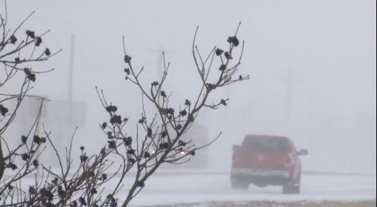
Northern Manitoba is taking the brunt of the winter storm, with blizzard warnings in effect from Thicket Portage (about 50 kilometres south of Thompson) stretching all the way to the Nunavut border. The city of Thompson, which saw schools close Thursday, is directly in the warning zone.
Forecasters warn of ferocious winds gusting 70-80 km/h combined with heavy blowing snow that will create near-zero visibility. Total snowfall is expected to reach 30-50 centimetres before the system moves out Saturday.
Highway closures have already been announced due to hazardous conditions and poor visibility. Snowplows are working overtime across northern routes, but roads are being re-covered almost as quickly as they're cleared.
Central Manitoba facing freezing rain and ice pellets
West-central areas including Flin Flon, Cranberry Portage, and Snow Lake are under winter storm warnings with a treacherous mix of freezing rain (5-10 millimetres) followed by 15 centimetres of snow expected.
In Flin Flon, the situation was dire Thursday morning. Ice pellets and freezing rain pounded the city alongside fierce winds and early thunderstorms, coating streets with a slippery glaze. Most of the city shut down for the day — all schools closed and bus service was suspended for both Thursday and Friday. Drivers who ventured onto the streets found themselves stuck on slick pavement as plows struggled to keep up.
Central Manitoba from The Pas through Gods Lake to the Ontario border faces heavy freezing rain warnings, with amounts potentially exceeding five millimetres expected to fall through Thursday evening.
Southeast under tornado watch
While northern regions battled snow and ice, Manitoba's southeastern corner faced an entirely different threat. Environment Canada issued a severe thunderstorm watch late Thursday afternoon for the region.
The system has the potential to produce destructive wind gusts up to 90 km/h, large hail, and heavy rainfall. Most notably, Environment Canada warned of the possibility of isolated tornadoes Thursday afternoon and evening — a rare but serious springtime risk.
Travel disrupted province-wide
The severe weather has disrupted transportation across Manitoba. School closures, bus suspensions, and road closures have left residents hunkered down. Drivers facing the northern conditions are being advised to scrape off vehicles frequently as conditions deteriorate rapidly.
Churchill and the Hudson Bay region were spared the worst warnings as of late Thursday afternoon, though the system's unpredictability means conditions could change.
Manitobans are urged to monitor Environment Canada updates closely as the system evolves through the weekend.
This article is based on reporting from CBC News. Read the original story at CBC News Manitoba.